


GeoRadioTomograph GRT-XX (Terrazond)
GeoReader Software supports both Russian and foreign GPR formats
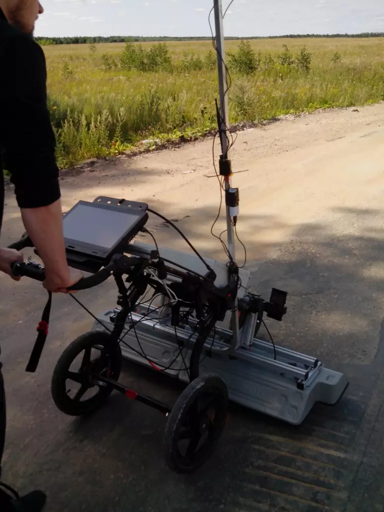
We, as a partner of the TerraZond company, offer for delivery the first in Russia multichannel georadiotomograph (3D GPR)

Let's see what it represents the equipment
For scanning continuous media, an antenna array with distributed receiving and transmitting high-frequency (HF) antennas of a wide range is used, which probes the environment from different angles
For the detection and localization of inhomogeneities mathematical used focusing method and radar technology with synthetic aperture, in which all the registered-array summed RF signals in the phase defined for each focusing point
Focusing is carried out by sequential summation of the received signals with equalization of the time delays of the pulses scattered by the point with the given coordinates. After performing the focusing operation for each point of the selected volume of space, a three-dimensional radio image is built
The focusing operation is carried out in the frequency domain using fast processing algorithms, which makes it possible to realize three-dimensional tomograms of the investigated space in real time
Data acquisition mode assumes standard switching of antenna pairs:

and switching the antenna pairs in the mode common midpoint:

The apparatus of the multi-GPR (georadiotomograf) is designed for the detection and spatial localization of objects and inhomogeneities hidden in various media (soil, road coverings, building construction, etc.)

Objects and inhomogeneities are detected, the dielectric constant of which differs from the background dielectric constant of the medium. The software allows you to obtain three-dimensional raster images of the explored space. It is possible to provide three-dimensional images layer by layer in the form of a set of images obtained at various sections of the probed volume along the selected direction, and three-dimensional visualization of inhomogeneities is also possible. Based on the obtained image, the operator makes a conclusion about the presence and location of buried objects and inhomogeneities within continuous media
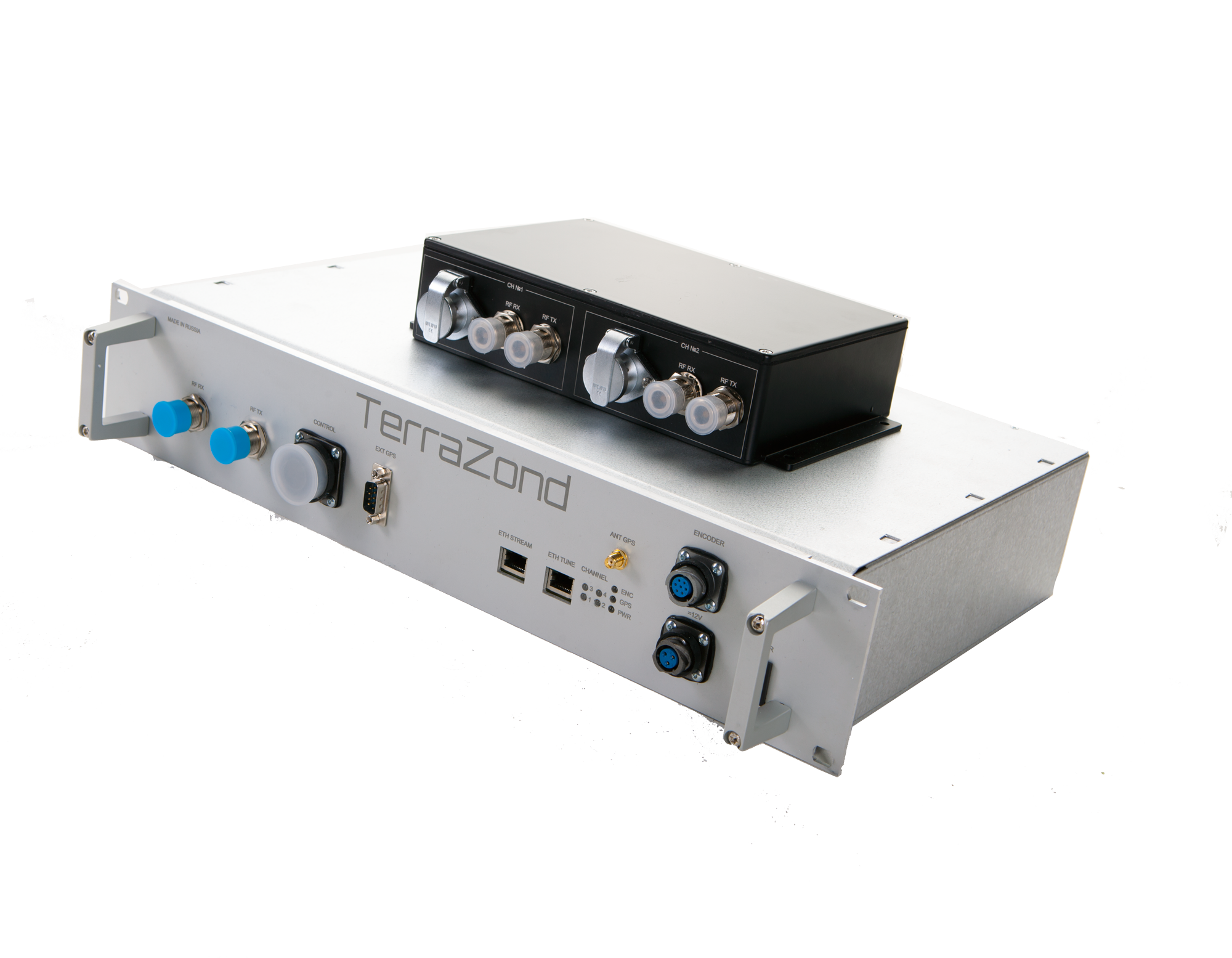
The GRT-3X georadiotomograph is a modular complex consisting of a unit for generating and receiving HF pulses based on a chirp generator and an antenna array module. In addition to the chirp block of the HF pulse generator and antenna modules, the equipment also includes a navigation block and a control computer

The built-in GPS / GLONASS navigation unit with the UDR system allows for accurate data association with the trajectory of the traveled path, even in dense urban areas. The antenna array has a modular construction principle. Each module consists of 4 receiving and 4 transmitting antennas for the range 0.5-3 GHz. Antenna modules can be cascaded into a bar to extend coverage for continuous media scanning
Multichannel 3D-GPR GRT-3X is the ability to collect up to 31 precisely parallel profiles with a transverse pitch between profiles from 7.5 cm. Maximum coverage per pass is 2 m 325 mm
Maximum resolution along the antenna array - from 10 cm, depth resolution - 1-2 cm, depending on the studied environment

Georadiotomograf effective for the following tasks:
- in construction: search and localization of various defects in wood, brick, reinforced concrete building structures; detection of fittings, hidden wiring, utilities; clarification of engineering-geological and hydrogeological conditions of construction sites; search for hidden defects in the walls of engineering structures, mines, tunnels, in supports and ceilings
- on roads, railways, airfields: determination of the thickness and structure of structural layers of pavement, railway embankments, runway elements, airfield taxiways; determination of the geometry of the roof of the natural foundation and ballast section; mapping of underground utilities; control of the conformity of the pavement structure, railway embankment, runways to design documentation; identification of unconsolidated and flooded areas; study of the features of the reinforcement of concrete slabs of the coating; study of engineering and geological conditions of areas subject to deformation; study of the geotechnical situation of the territories adjacent to airfields
- in housing and communal services: determination of the location of underground communications - pipelines, cables, collectors, drainage networks, etc.; monitoring of the condition of underground space during preventive maintenance work on hydraulic testing of water supply networks
- in archeology: localization and analysis of archaeological objects - burials, artifacts, household items; mapping of ancient structures - identifying the location of the foundations and walls of destroyed buildings; determination of the thickness of the cultural layer
- in security: search for criminal graves, caches, explosive devices, people under avalanches; identification of unauthorized tie-ins into main pipelines
the result of processing in the GeoReader Software:
- defining layer boundaries

- setting the color attributes from the values of the thickness of asphalt concrete on radarogram GRT-3X

- visualization of deviations in the thickness of asphalt concrete on the trajectory of the road in relation to the coordinate system

- construction of transverse GPR slices (along the antenna array)
Since the processing of GRT-XX radarograms is currently carried out only in the GeoReader Software, we provide constant assistance in the development of the TerraZond company. Keep for updates!
Buying a GRT-XX georadiotomograph from us, you get 1 year of free use of the GeoReader Software!