The survey of areal objects
The main theses
Often, during construction work, contractors are faced with the need to obtain additional information about the construction area. This is primarily due to the possibility of damage to engineering communications that were not found during the design and survey work. In addition, without additional geophysical survey, engineering and geological surveys of the development area are of the nature of point observations, which does not exclude the likelihood of the impact of "missed" dangerous engineering and geological processes and phenomena at the construction site
TIM LLC, being the developer of software for automated processing of large volumes of GPR data, as well as methods of geophysical research using the GPR method, is directly involved in the implementation of production tasks, which allows software solutions of its own design to pass practical testing on real objects
This page contains a description of the main stages of work and the results obtained in the course of one of such studies
The purpose of the work was to assess the presence of alleged buried historical artifacts, incl. underground passages on the territory of the city park under reconstruction in the town of Nerekhta, Kostroma region. In the course of the work, the methodology of a comprehensive GPR survey of the object was applied, including geodetic and geophysical work with excavation of the soil base for selective verification of the survey results. Based on the results of the GPR survey, anomalies caused by increased soil moisture were found, as well as the location of anomalies and local objects buried in the ground
Description of the object and research methodology
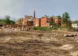
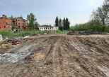
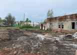
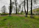
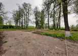
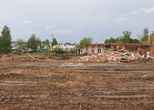
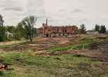
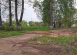
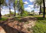
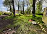
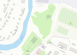
The object of research is the reconstructed city park located in the town of Nerekhta, Kostroma region. It is located next to the valley of the river of the same name. The development area includes the existing park, as well as adjacent land with buildings prepared for demolition. The total survey area was at least 1 hectare in 2 working days. The work area is predominantly flat, with the exception of the slope of the river bed

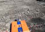
The construction site in most of the territory had a relatively flat surface of the soil base, which made it possible to tow the antenna units of the GPR

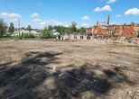
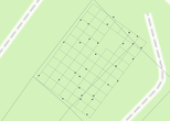
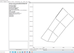
At the same time, in some areas there were obstacles in the form of low buildings and structures, shrubs and woody vegetation, construction waste and stored materials. Before the work was carried out, a reconnaissance survey of the site was carried out, on the basis of which it was decided to carry out a geophysical survey in 2 stages: the collection of GPR data by a network of orthogonal geophysical profiles that cover the work area as much as possible, as well as detailed surveys in individual areas with identified structural inhomogeneities. Since the construction site had limitations for the uniform distribution of the georadar passages, and the terrain conditions did not contain characteristic objects for accurate georadar pass profiles, geodetic referencing was performed during geophysical work. Namely, the survey area was marked with a signal tape fixed with electrode pegs. The location of the pegs and key marking points was coordinated using satellite equipment in RTK mode

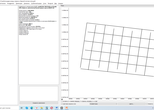
At the same time, in accordance with the stages of work, 2 schemes of the GPR passageways were created: a large orthogonal network throughout the entire territory and a dense one in some areas:

However, even in areas with a dense survey network of orthogonal georadar passages, it was necessary to carry out their breaks along the path of the georadar course in the places of growing trees and stored building material

It should be noted here that the GeoReader Software package contains a large set of functionalities for tying GPR profiles based on the results of geodetic surveys with various types of equipment: a satellite receiver, a total station, a laser scanner. Therefore, when performing field work, an engineer does not need to thoroughly plan the location of the survey network sections in order to eliminate all obstacles in the path of the GPR passage, since the post-processing procedures provided by the logic of the GeoReader Software package allow building schemes of GPR passes of any configuration and complexity, and also allow correct processing of geophysical information. within the established patterns

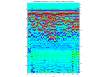
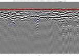
The first stage of fieldwork made it possible to determine the areas of the most heterogeneous structure of the soil base of the survey area. Inhomogeneities include signs of the presence of reflections from local objects, characteristic bends of the in-phase axes on radarograms, as well as anomalies of the amplitude-frequency signal


In the areas of detailed survey, a network of orthogonal sections of a rectangular GPR passage was broken up and coordinated with a step between parallel passes of 2.5 m

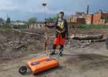
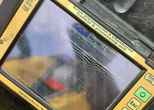
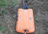
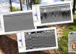
The survey was carried out by the Oko-2 series georadar with antenna units of the central frequency of 250 and 150 MHz. GPR profiles of the last antenna turned out to be the most informative, and therefore, in the process of cameral work, all the main conclusions were drawn on the basis of its data
It should be noted that the GeoReader software package supports data formats of various GPR equipment, both domestic and foreign. This allows the solutions offered by TIM LLC to be as versatile as possible. At the request of the client, our company can carry out the selection of GPR and geodetic equipment for fieldwork, integrate the equipment into the customer's vehicle in the case of work at linear facilities, teach the main methods of GPR survey developed by us, and also take part in the client's first projects, helping him adapt as quickly as possible to work with a GPR to achieve the desired effect as soon as possible
The towing of the GPR antenna units was carried out according to the "snake" principle in such a way that their center was exactly located above the signal strip stretched along the soil base

To fix the ordinal number of the GPR profile, the engineer of TIM LLC made outlines of each section. Upon completion of the fieldwork, the layout of the georadar passageways using pegs and a signal tape was completely dismantled. TIM LLC pays great attention to the culture of production and environmental protection, so in our work we use techniques and tools to prevent pollution of the customer's facility
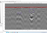
Cameral works on processing and interpreting GPR data was performed in full in the GeoReader Software package. First of all, GPR projects were created, which contain information about a specific set of GPR profiles. As a rule, a project is created for a separate survey area (site) or a separate GPR antenna. In this case, 6 GPR projects were created for 4 work areas, 2 of which included projects of detailed GPR surveys. Each project includes a set of GPR profiles with metadata about them, which are generated automatically when collecting GPR data using standard software (in this case, the recording was carried out in the GeoScan32 software). In addition to each GPR profile, a cameral engineer can add additional metadata in the form of a comment to the file

The first procedure for processing GPR profiles is their coordinate referencing. If the coordinates of the GPR trajectory are recorded by a satellite receiver directly connected to the GPR, they are automatically read by the GeoReader Software package. In this case, for example, for equipment of the OKO series, data collection can be performed in any standard software: GeoScan32 or Kartscan. In either case, GeoReader recognizes georeference files in the native format of GPR OKO and correctly determines the trajectory of the antenna unit even taking into account its offset relative to the satellite receiver antenna. Also, the GeoReader software package allows you to add an external GPR trajectory, for example, obtained directly by satellite equipment in RTK mode or calculated in post-processing. To do this, it is necessary to be guided by the provisions of the field work methods developed by TIM LLC, which are included in the delivery set of the GeoReader Software package. And finally, the last method of georadar profiles coordinate referencing, which was just used in this work, does not imply direct connection of satellite equipment to the georadar. However, the existing coordinates of the start, end and nodal turning points can be added to the GPR profile both by manual input and by importing the corresponding text file

After the coordinate referencing of the GPR profiles, their processing and interpretation were performed, namely, batch processing procedures, including: amplification, filtering, removal of the direct transmission signal, attribute analysis of the signal, spectrum and images of the GPR profile
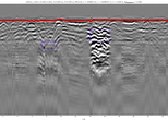
Further, on the GPR profiles, reflections from local objects were determined and vectorized based on the presence of hyperbolas, as well as anomalies, incl. using computer vision algorithms

Since each GPR profile has a coordinate reference, using the GeoReader Software package, the plan coordinates, as well as the depth of the detected local objects and anomalies, were exported in the format of a CSV test file. It should be noted that the GeoReader Software package allows you to export the results of a GPR survey in exchange formats for CAD and GIS applications. Thus, depending on the software environment in which the results of geophysical surveys will be analyzed in the future, the engineer has the ability to directly import data into the software product used, for example, Autodesk, Bentley, ArcGIS, MapInfo and similar
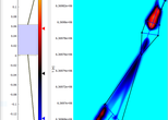
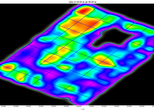
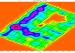
Since the GeoReader Software package allows you to work not only with individual GPR profiles, but also with interpolated horizontal sections built from a series of longitudinal profiles, amplitude maps at different depth ranges were created and analyzed as part of the survey. The amplitude map allows you to detect objects of a characteristic shape in plan (extended communications, remains of the foundation or walls of buried buildings), to perform their vectorization at different depths for subsequent imaging on the ground. Amplitude maps were built over the entire surveyed territory of the park, including 2 areas of detailed GPR survey. Horizontal slices were analyzed to a depth of 8 m. When constructing amplitude maps, the original (or amplified) and filtered signal, as well as the results of attribute analysis, were used

Main results and conclusions
Based on the results of the work, the customer was provided with a report, incl. description of the survey methodology, analysis of the results of the work performed, conclusion and graphic applications

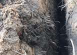
Based on the results of the work, the customer was presented with interpreted files with GPR profiles, on which the locations of local objects and structural anomalies of the soil base were determined. Information about the location of the specified objects with a planned coordinate reference and information about their approximate depth of laying was prepared in the format of a text file, and also included in the report in the form of appendices in tabular form. Due to the fact that the GPR does not determine the type of object and the nature of the detected anomaly, the verification of the results of geophysical survey is carried out by means of destructive methods (excavation of workings). At the same time, signs of anomalous structure of the subsoil were found on the amplitude maps. Long objects of regular shape were observed at a depth of 3 to 4 meters in one of the detailed survey areas

Since at the stage of operation of the facility, from the point of view of ensuring safety, the most important is the detection of underground cavities filled with water or air, the specified area was subject to priority inspection by means of excavation. On the basis of the tables presented to the customer with the planned coordinates and depth of laying, as well as graphic materials with the ranges of the detected objects marked on the map, they were carried out on the ground and the excavation was made using an excavator. According to the results of the work, an area of influence of a negative geological phenomenon was indeed discovered, namely, local flooding of the base by groundwater

At the same time, there were no underground cavities, which the construction organization feared, in the area of the anomaly. At the same time, based on the results of the work, the customer:
- received additional continuous information about the object throughout the entire survey area, which could not be obtained within the framework of drilling operations alone at the stage of geotechnical surveys;
- carried out targeted tunneling of a working according to the results of a non-destructive areal survey and made sure of the safety of the territory for further operation;
- received a statement of the location of local objects and other structural anomalies of the subsoil, which, both directly and indirectly, make it possible to carry out control excavations on the territory in order to discover historical artifacts of archaeological value for the state
Note that the search for local objects and anomalies on the GPR profile is not limited to the capabilities of the GeoReader Software package. The software is effectively used when performing engineering and geological surveys, surveys and quality control in the construction of highways. The developed functionality of the GeoReader software package allows you to control the thickness and uniformity of the thickness of the structural layers of the pavement, the uniformity of the properties of the materials of the bases of road structures, soils of the subgrade and its underlying base. The approaches of collection and processing of ground-penetrating radar data, applied by TIM LLC, provide the possibility of full accounting of the results of ground-penetrating radar surveys in the design and operation of highways using information modeling technology
To get acquainted with the capabilities of GeoReader Software, we suggest you try the trial version of the software
Fill out and send to post@geotim.ru an application of the following form Application for TRIAL version of GeoReader Software