


GeoReader Software package
The GeoReader Software package is designed for high-quality and productive data processing of a geophysical non-destructive testing device - Ground Penetrating Radar
GeoReader consists of 3 main applications: processing a package of radargrams (project manager – GeoReader Project), one radargram processing (GeoReader) and working with amplitude maps (GeoReader AmplitudeMap).
GeoReader Project
The module for batch processing of radargrams - GeoReader Project, is a basic application for project management. It combines all the individual radargrams, added to the project by the user
The main principle of work in the project manager is simultaneous management and processing set of files - the GeoReader Project module allows you to edit a series of radarograms and apply various processing procedures to them, saving time

GeoReader Project functionality:
- data import and edit a series of GPR-data
- export results interpretation series GPR profiles in CAD and GIS
- work with the path for a series of GPR data, binding with geodetic accuracy
- attribute analysis of a series of GPR-data
- displays the layer thickness of the pavement in the plan window in different colors
- the binding of GPR-data to survey the terrain on the pickets or kilometers, traveled by road
- the construction of the GPR cross-sections (along antenna) on the parallel profiles with multi-channel GPR data

GeoReader Project allows batch import of data into the project
Almost all domestic and some foreign equipment is supported. In terms of data processing, GeoReader Project applies to all files batch procedures for attribute analysis, creation and removal of layers in which the operator forms various objects, design settings in accordance with the project documentation of the object, separation of multi-channel radargrams into components, calculation of the soil model in all wells of the project or for the known average speeds of the electromagnetic signal in layers, typical amplification functions such as, direct wave removal, trimming, filtering and profile reversal
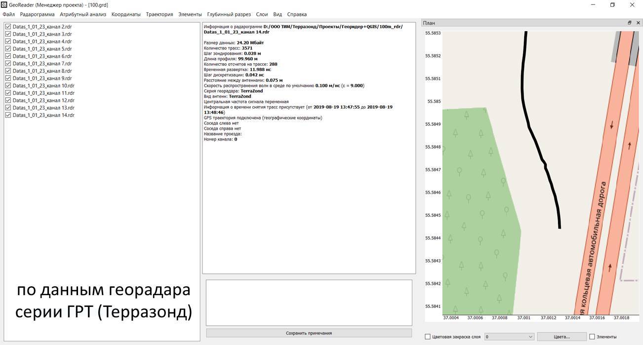
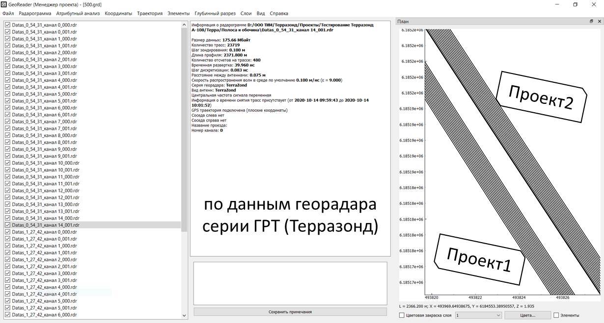
If there are spatial coordinates for GPR profiles, the project manager allows you to automatically import the trajectory of the GPR. Performing operations on its displacement in plan and height. If the trajectory is calculated in post-processing in differential mode, it can also be imported into GPR profiles. It is not a problem if the trajectory of GPR is determined at the reference points using a total station, it can also be imported into the project. The location of all profiles is displayed in the plan window
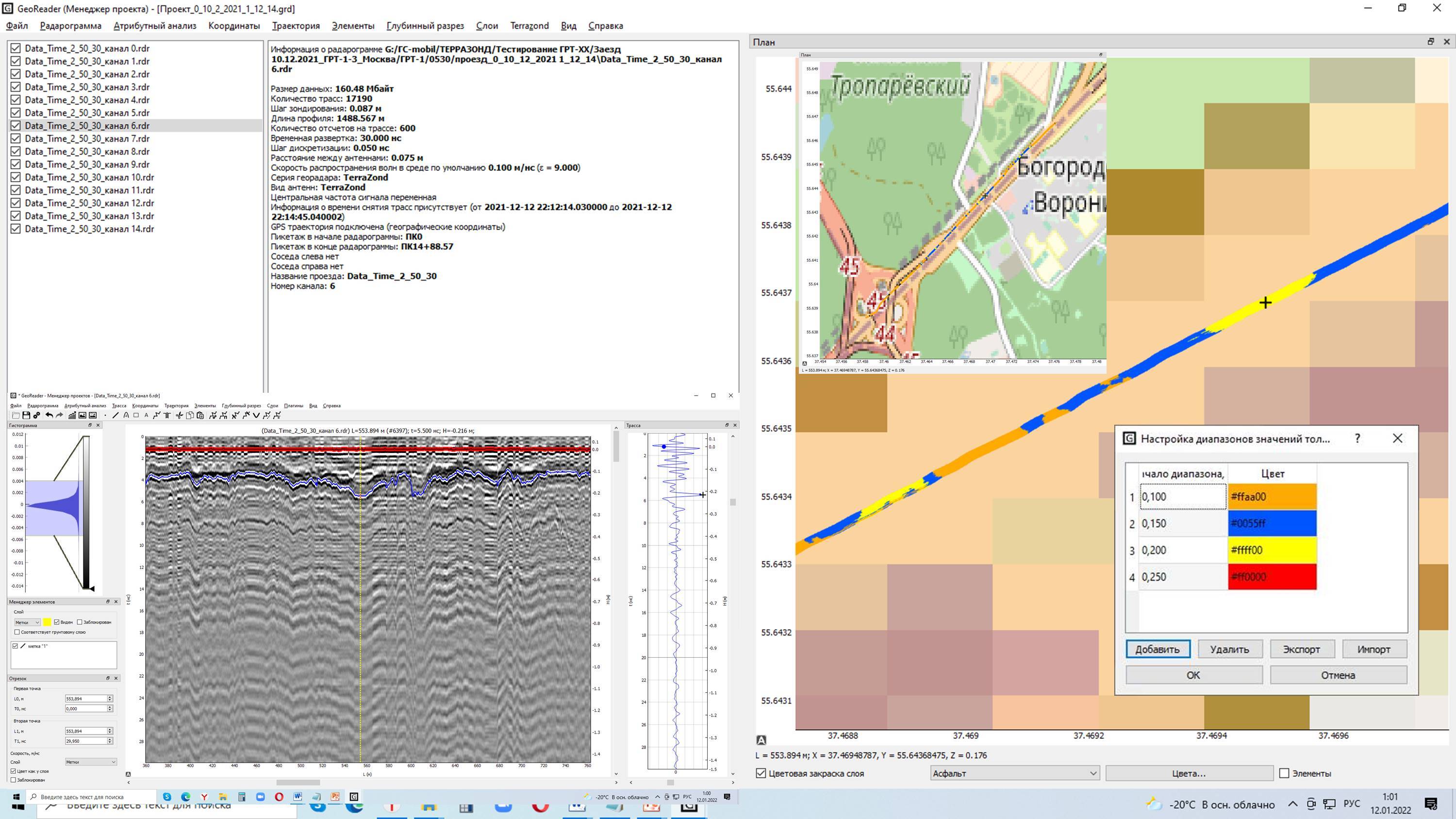
GeoReader Project is synchronized with two other applications of the software package, allows you to open a GPR profile for processing or activate the construction of amplitude maps. All data, be it a trajectory, a GPR profile or an amplitude map, are inextricably linked to each other by common coordinates, so navigation between them within the framework of working with the project is performed synchronously
When exporting data to GIS and CAD applications or other cartographic services, the attributes of GPR profiles are also unloaded, allowing you to synchronize the work of third-party programs with the GeoReader software package
It is worth noting that the GeoReader software package does not seek to replace the functionality of software familiar to engineers, such as AutoCAD or, for example, ArcGIS. If an engineer is used to working with it, GeoReader will simply export the results of the GPR survey in an exchange format for the convenience of their further analysis and use in solving applied problems
GeoReader
Almost all the main work on the processing/interpretation of the GPR profile is carried out in the processing module of a single radargram – GeoReader:
- data import and editing of the radargram
- exporting the results of the radargram interpretation to CAD and GIS applications
- working with the trajectory
- layers boundaries searching
- boreholes model creating
- automatically determining the thickness of asphalt concrete without drilling
- layers model creating
- attribute analysis
- joint analysis of GPR data and other diagnostic systems, including shock loading equipment FWD
GeoReader supports 8 (eight) different data formats of Russian and foreign GPR-equipment (ground penetrating radar) - source data imported from these DATA formats:
- TXT for Krot software (LOZA GPR)
- GPR and GPR2 (for GPR OKO series)
- DZT (for GSSI GPR)
- RD3 (for MALA GPR)
- DT1 (for Sensors & Software GPR)
- TRZ (for the "GRT-XX" Terrazond GPR)
- SGY (universal seismic data format, incl. GPR data ZOND)
GeoReader, like the CAD application, allows you to initially set the classification of objects created as part of a project's work. To do this, a separate layer is created for each type of objects. At the same time, for such objects as a road or railway, a runway or a taxiway, it is possible to establish the mutual arrangement of layers according to the design documentation. This makes it possible to provide a rigid hierarchical relationship of the spatial arrangement of structural layers when exporting data to other applications
Objects that can be created in GeoReader: placemark, segment, point, polyline, rectangle, diffraction hyperbola, borehole, text
There are 2 main approaches used to create layer boundaries: manual and automated
With the manual approach, the operator creates a set of points in each layer and connects them. The point can optionally be tied to the signal phase or set by an engineer "by eye"
The automated approach is implemented as an additional plugin to the GeoReader software module, with its own separate settings - the search can be carried out by the original or enhanced trace, image or the result of attribute analysis
When calibrating the GPR profile in GeoReader software module (establishing the exact position of the boundary between the geological layers of the structure under examination), one of the tools is to take into account the drilling results
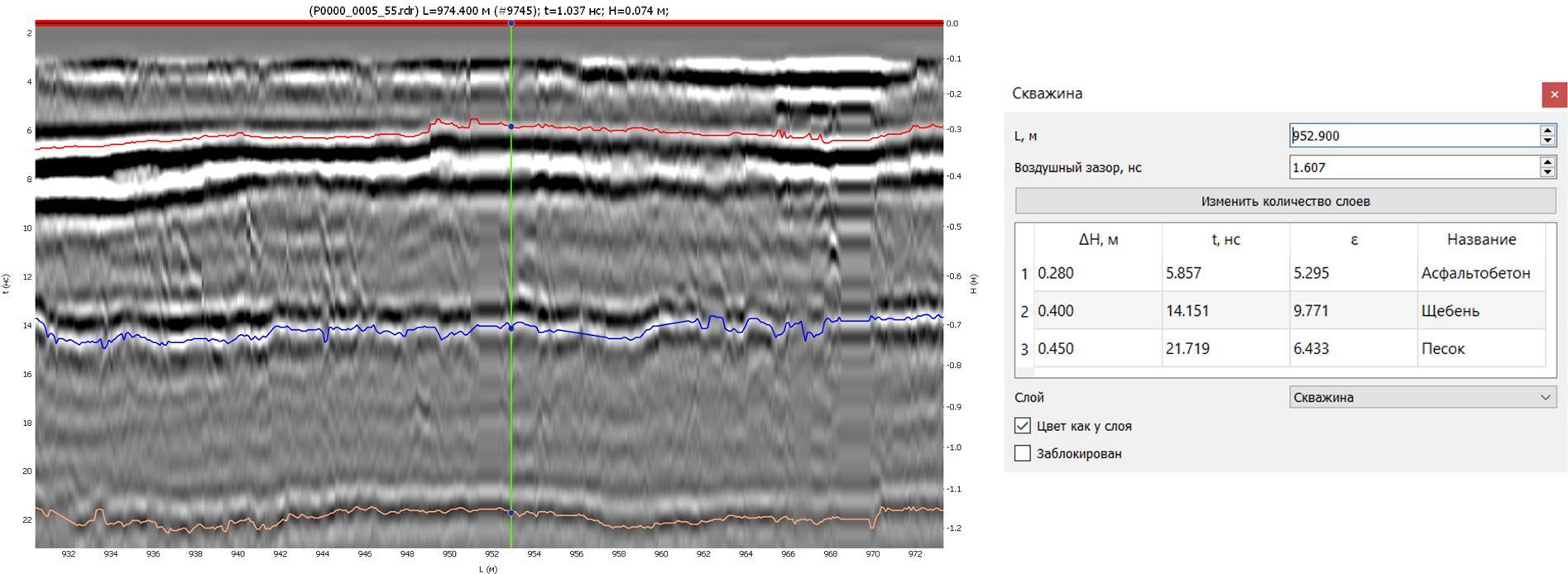
Since GeoReader software package is a part of the technological process, the application provides for the possibility of creating project wells, which become actual or deleted as the project is implemented. The TIM LLC company's work methods of usually provide for preliminary marking of boreholes on GPR profiles in the most preferred places. Then the coordinates of the location of the boreholes are taken out on the ground. If the borehole was drilled in a pre-designated place, it subsequently becomes a design one, and material data and the actual thicknesses of the layers are entered into the GeoReader application in the borehole element. If the borehole was moved in the field, its location is coordinated and added to the project using these coordinates
The GeoReader module interface of the borehole window will quickly tell an experienced user whether it was drilled exactly according to the project or there is a deviation in its position, since control is carried out by the values of the propagation velocity of electromagnetic waves in the layer or by the dielectric constant. If the speed values go beyond the reference values, an error is obvious at the field stage of the work
Not infrequently, boreholes in a project may not be present on every GPR profile. Subsequently, when calculating the soil model in the entire project, data from a total limited number of boreholes are used
Part of the GeoReader module functionality is implemented as separate plugins
Thus, the possibilities of automated border search have already been noted earlier. A feature of the plugin is the unique search algorithms. They are developed within the framework of a research work of annual duration and have corresponding patents. These algorithms work more accurately than in similar solutions
Many people would like to be able to determine the thickness of the pavement layers without drilling with an acceptable error. To date, this is possible for the first layer, and, as a rule, it is a package of asphalt concrete layers, or a freshly repaired asphalt concrete coating. The calculation method is based on comparing the amplitude of the reflection of an electromagnetic signal from the surface of asphalt concrete with the reflection from the surface of an absolute reflector - a metal sheet. Approbation and comparison of this approach with traditional drilling calibration showed comparable results. Unfortunately, this technology is not suitable for the underlying layers of road structure
GeoReader allows you to import external graphs with coordinate or linear reference into a GPR profile. One of these is a graph of changes in elastic deflection from the impact of a shock load on the surface of the road surface. Joint data analysis has already begun to show its effectiveness, so according to shock loading data, the places of increased deflection are determined, and GPR helps to explain the reasons for the decrease in the strength of the pavement in this place
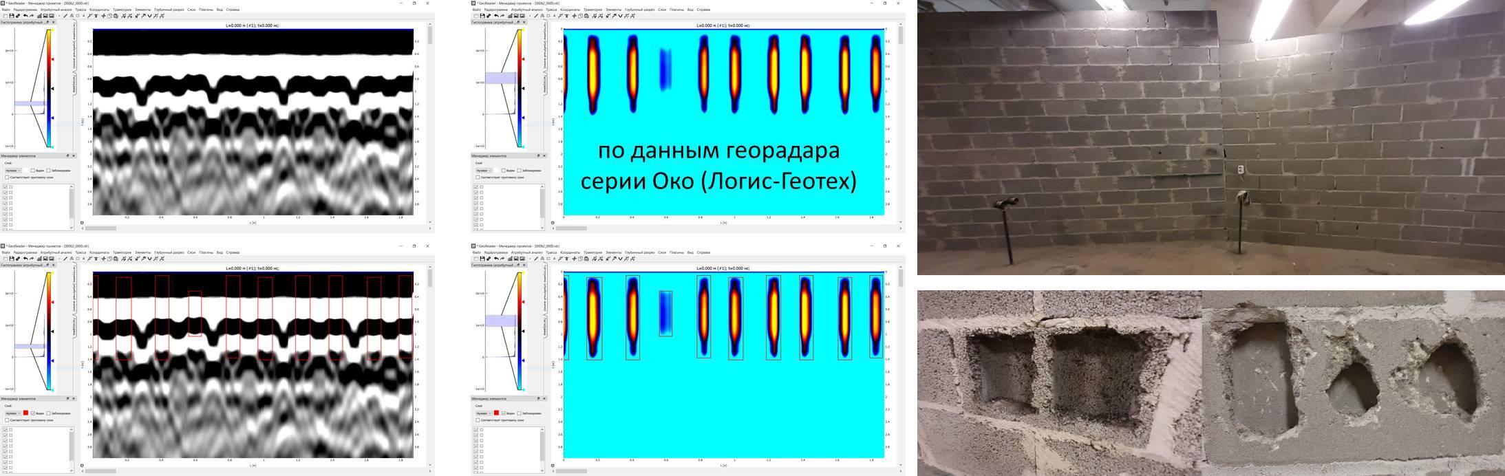
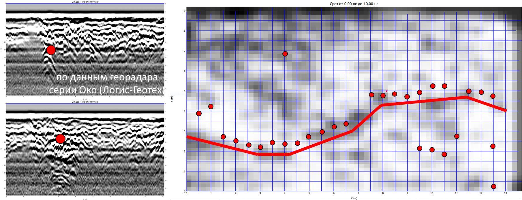
The automatic anomaly search plugin works using attribute analysis algorithms. The automatic search for structural anomalies performs the function of automatically determining physical deviations in the examined structure from the design parameters by identifying areas of change in the attribute field of the signal and the texture of the GPR profile. The automated search for structural anomalies can be used both from the block for processing a package of radargrams (project manager), and from the block for processing a single radargram
Anomalies identified by the results of attribute analysis are automatically detected using digital image processing. The figure below shows the detection of technological voids in building blocks, the display of which on the initial GPR profiles is not sufficiently objective
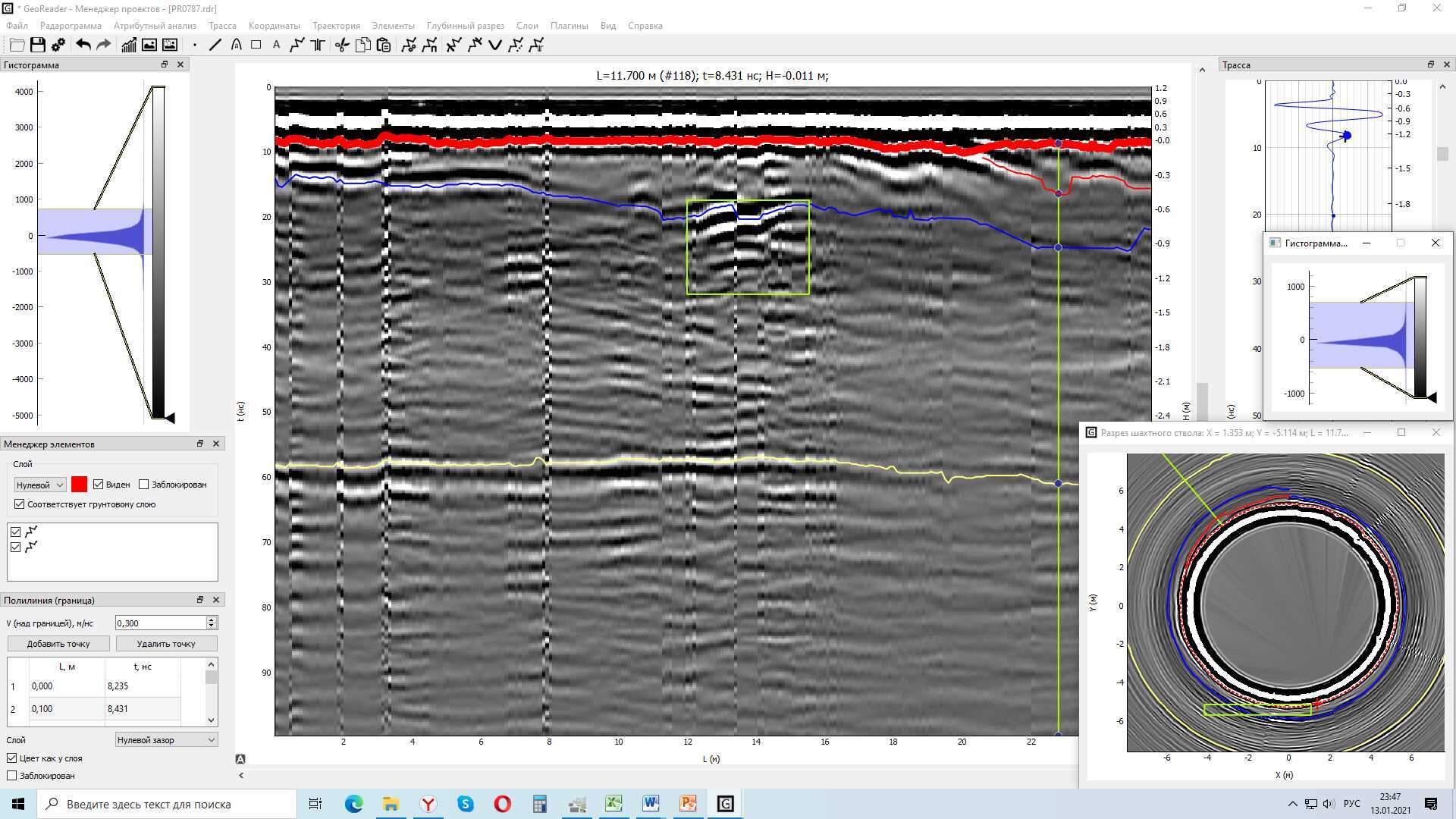
The plugin for converting the original radargram into a ring one allows you to get a ring image. This is practical when analyzing a GPR profile taken along the mine shaft - specifying the initial coordinate of the profile, or the side of the world, allows you to determine the exact position of the detected voids, or other formations
GeoReader software module allows you to import the GPR trajectory from external devices, export it to the Google earth map. The results of the interpretation of radargrams can be downloaded from GeoReader in the coordinate system of the project in *.csv, *.shp, *.dxf formats to software packages such as Autodesk AutoCAD, Bentley Microstation, ESRI ArcGIS, QGis and similar
The working area of the processing unit of a single radargram of the GeoReader software package consists of the specified areas:
- element manager (1),
- radargram (2),
- trace (3),
- histogram (4),
- element menu (5)

GeoReader AmplitudeMap
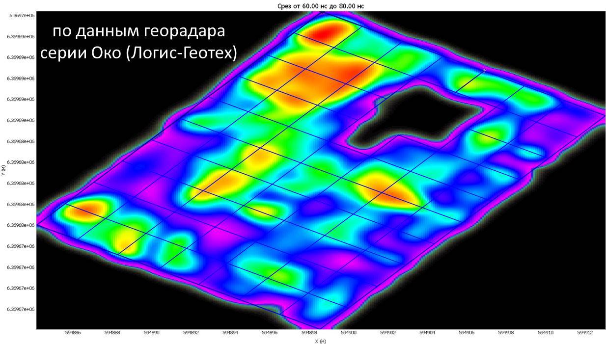
The ideology of GeoReader AmplitudeMap is the construction of interpolated horizontal slices based on a series of vertical GPR profiles of any configuration. Whether it is parallel longitudinal profiling or orthogonal survey network
The Amplitude Maps module (AmplitudeMap) allows you to build horizontal slices of areal and linear objects, adjust the detail of the image, use the original radargrams or profiles with amplification as substrates, as well as the results of attribute analysis
When using multi-channel GPR equipment, it is possible to build an amplitude map based on a series of parallel longitudinal profiles, adjust the ranges of construction of secant planes and switch between them to search for objects at different depths
Using a single-channel GPR, when recording a grid of orthogonal profiles, an amplitude map can be built knowing only the coordinates of the beginning and end of the profiles. GeoReader AmplitudeMap takes into account both longitudinal and transverse profiles when constructing amplitude maps. The shape of the shooting network does not necessarily have to be rectangular, some profiles may be longer, some shorter, and there may be shadow areas inside the perimeter of the shooting, for example, in the locations of obstacles for recording an unbroken profile
The display of the amplitude map can be different: in the form of interpolated maps or along separate profiles. The user chooses the mode that is convenient for him
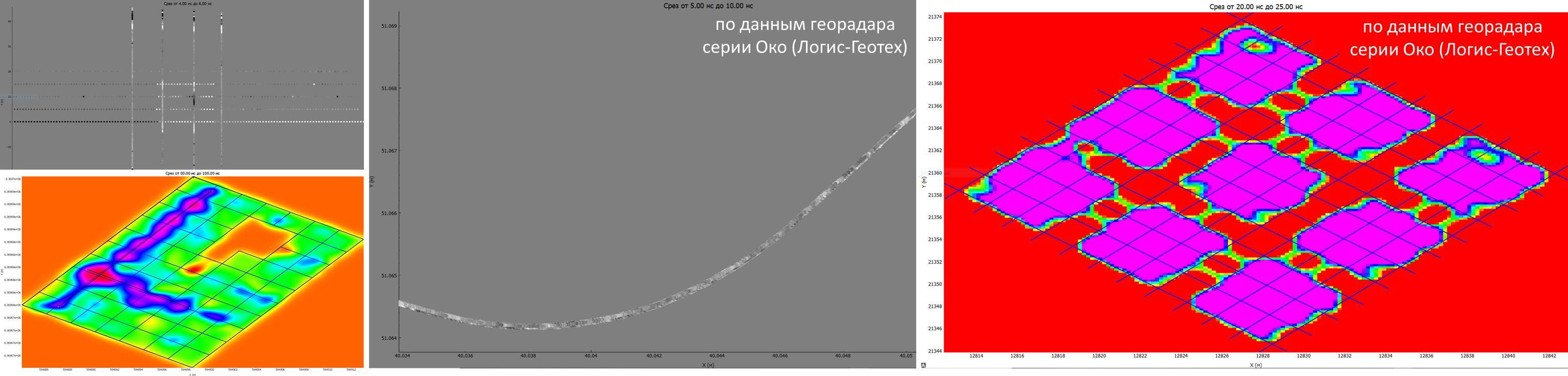
In addition to the amplitude of the reflected signal, amplitude maps allow you to display the results of attribute analysis. Also, amplitude maps are ideal for searching for building structures buried underground, the location of reinforcement in concrete slabs, concrete slabs themselves under asphalt concrete, and of course local voids, subsidence, waterlogging areas
By mapping out places of characteristic reflections from engineering communications on GPR profiles, you can display them on amplitude maps at a given depth. Comparing the picture of a horizontal slice with the location of point objects, it is possible to determine the direction of tracing engineering communication
Hardware requirements of the GeoReader software package
- operating system - Microsoft Windows 7, Microsoft Windows 10 (32 or 64 bit),
- processor frequency - at least 1 GHz,
- RAM - at least 2 GB,
- video card - at least 256 MB with OpenGL support,
- at least 2 GB of free disk space.
A technical description and examples of solving typical tasks during GPR surveys are presented on the TIM LLC YouTube channel (put likes, we will be glad):
Briefly, the capabilities of the GeoReader software package are presented here:
The functionality of the software package and operating instructions are formulated in the user manual GeoReader_manual
Read the instructions for installing the TRIAL version or the instructions for installing the FULL version
For the purposes of user interaction, the processes that ensure the maintenance of the GeoReader software lifecycle are described
GeoReader Software package's advantages
The main differences between GeoReader software and software products available on the Russian market are as follows:
1) GeoReader is a symbiosis of geophysical and geodetic methods for solving applied problems
2) it is possible to create a three-dimensional model of the underground environment and export it to CAD/GIS systems
3) binding to the coordinate system of the project is carried out with high accuracy
4) the requirements of industry regulatory and technical documents are supported
5) it is much more convenient to work in GeoReader, since it is ideologically arranged like a CAD – there is a radargram on the background of the application's window, while you can work interactively with analytics elements. Working with data is automated
6) GeoReader implements the function of calculating the velocity parameters of the medium by the method of processing hodographs (OGT) and the method of amplitude analysis. This makes it possible to significantly increase the accuracy of determining the thickness and properties of the soil layers
7) GeoReader allows you to build amplitude maps (C-scan mode) when performing an area survey in order to search for underground utilities, buried structures, etc.
8) in practice, with the GeoReader software package, it is possible to justify the inexpediency of control drilling and reduce its number
9) support for 8 different formats of Russian and foreign GPR equipment
How can to get a trial version by the GeoReader software package?
To clarify the cost of GeoReader Software package, as well as
try to work, or
purchase a License for the right to use the GeoReader Software, you can by upon request at post@geotim.ru
Fill out and send the application form of the following Application for the TRIAL-version of the GeoReader Software
The GeoReader Software package is distributed under the terms of a simple (non-exclusive) license for the right to use