PROSPECTS FOR INFORMATION MODELLING OF ROAD PAVEMENTS
R. A. Eremin1, candidate of technical sciences, Deputy Head of the Department of Road Design Methods
A. M. Kulizhnikov1, Doctor of Technical Sciences, Professor, Head of the Department of Road Design Methods
N. G. Pudova1, engineer
F. A. Grishin1, Engineer
D. R. Galimov1, engineer
1 FAI "ROSDORNII", Moscow, Russian Federation
Since 1 January, 2021, the technology of information modelling is used in the Russian Federation to draft the design documents for transport infrastructure facilities including motor roads if their reconstruction is funded from the federal budget and extra-budgetary sources
The requirements for the rules of development and maintenance of information models are specified by the Decision No. 1431 of the Government of the Russian Federation, dated 15 September, 2020. Thus, the construction industry and, particularly, road industry demonstrates active transition to the stage of industrial application of information modelling technologies
The article contains the results of researches in the area of application of georadar surveys and mobile laser scanning for information modelling of motor road pavements. The experience of 3D modelling of road pavements available in Russia and abroad is analysed. The key provisions of the procedure for the development of information models of road pavements and for their attributive filling are described, and proposals are given for practical application of these models
The importance of road pavement preservation tasks is noted, and the implementation is proposed for large-scale approach to the information modelling of road pavements; this implementation includes, as a stage, the development of the national industry-specific regulatory document
Key words: highway, information modeling, BIM, GPR, mobile laser scanning, pavement, point cloud, three-dimensional model, weakened zone
INTRODUCTION. LEGAL REGULATION IN THE FIELD OF BIM IN RUSSIA
Following the order of the Ministry of Transport of Russia (dated September 17, 2020 No. AK-177-r), it was established that from January 1, 2021, the preparation of design documentation for transport infrastructure facilities is carried out using BIM
Thus, the construction industry and, in particular, the road sector is actively moving to the stage of industrial application of BIM technologies
For highways, new pre-standards have been put into effect:
- PNST 505-2022 “Public automobile roads. Rules for describing the components of information modeling” [1]
- PNST 506-2022 “Public automobile roads. Rules for the formation and application of information models at various stages of the life cycle” [2]
PNST 506 [2], among other things, establishes the rules for the formation of an engineering survey model, and PNST 505 [1] establishes the rules for the digital representation of road elements. The objects of digital representation of the relief model and geological and geotechnical study of the road are points, polygons, polylines (including 3D), surfaces and 3D bodies
There are different methods can be used to create a model of the relief and geological structure: traditional (geodetic surveys using tacheometers and geotechnical surveys using boreholes) and progressive (navigation satellite systems, aerial photography, laser scanning, ground penetrating radar research in conjunction with destructive methods, electrotomography, etc.). The advantages of progressive methods are obtaining a more detailed data array, which increases the completeness and reliability of the results of engineering surveys, as well as work productivity
EXPERIENCE IN MODELING PAVEMENTS IN RUSSIA AND ABROAD
Combining the results of laser scanning and GPR surveys began to be practised in the world quite a long time ago [3]–[5], and the possibilities of integrating such models have been repeatedly proposed in Russia for the last five years [6], [7]
One of the most recent studies is noteworthy in that it was carried out during the period of the highest level of maturity of BIM technology in road construction [8] and the development of the IT industry, but the principles of modelling are based on fundamental research in the early 2000s
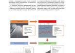
In 2022, the authors Fabrizio D'Amico, Alessandro Di Benedetto et al. from the Engineering Department of the University of Rome (Università degli studi Roma Tre) and the Civil Engineering Department of the University of Salerno (Università degli Studi di Salerno) published an article [8], which contains a description experience in creating three-dimensional pavement models based on laser scanning and GPR survey data. The workflow for creating a three-dimensional model by the above researchers is shown in Figure 1
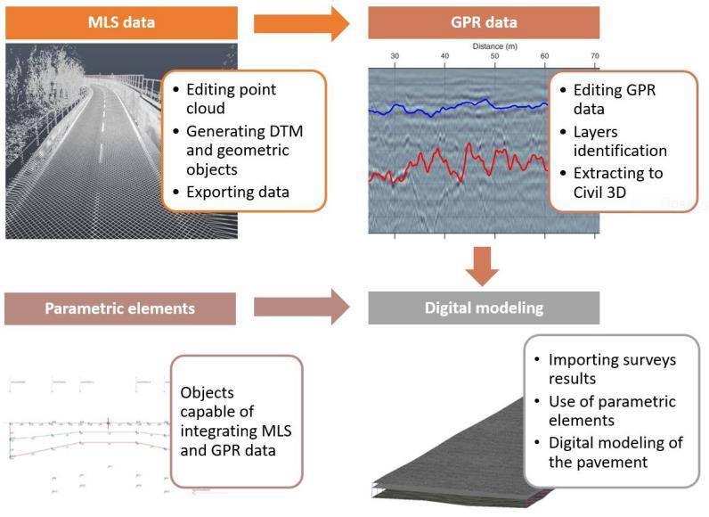 Figure 1 - Proposed workflow for the integration of non-destructive survey data in a building information modeling (BIM) model
The authors repeatedly focus on the possibility of using digital models of pavements to manage their condition and prescribe the necessary repair and restoration measures. In the context of the approaches used in BIM, the authors propose using such models to describe the initial state of the road pavement after construction and then update the digital model during the asset's life cycle through systematic monitoring surveys [8]. There is an example of the cross-section in Figure 2, which represents the geometry of pavement layers. You may see prospective areas of water accumulation
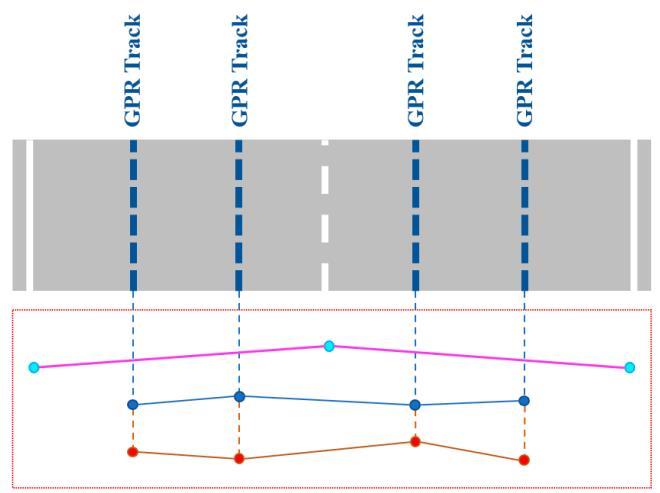
Figure 2 - The geometry of the layers of the road structure in cross section
The collection of spatial data along the entire length and width of the pavement makes it possible to model its structure and condition and assign various attributes to the modelled layers, such as the material from which they are made
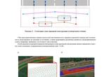
By analyzing the geometry of the surface and the interfaces between the pavement layers, it is possible to determine the sections of the base layers subject to water saturation (Fig. 3) [8]
a) b)
a - slope patterns in a certain area of a layer of the pavement;
b - drainage basins on a layer of the pavement with an indication of those that form a depression on the surface
Figure 3 - Analysis result on the digital surfaces generated by the model
Figure 4 shows an example of visualization of a three-dimensional pavement model [7] built in the same way as described by Italian researchers [8]
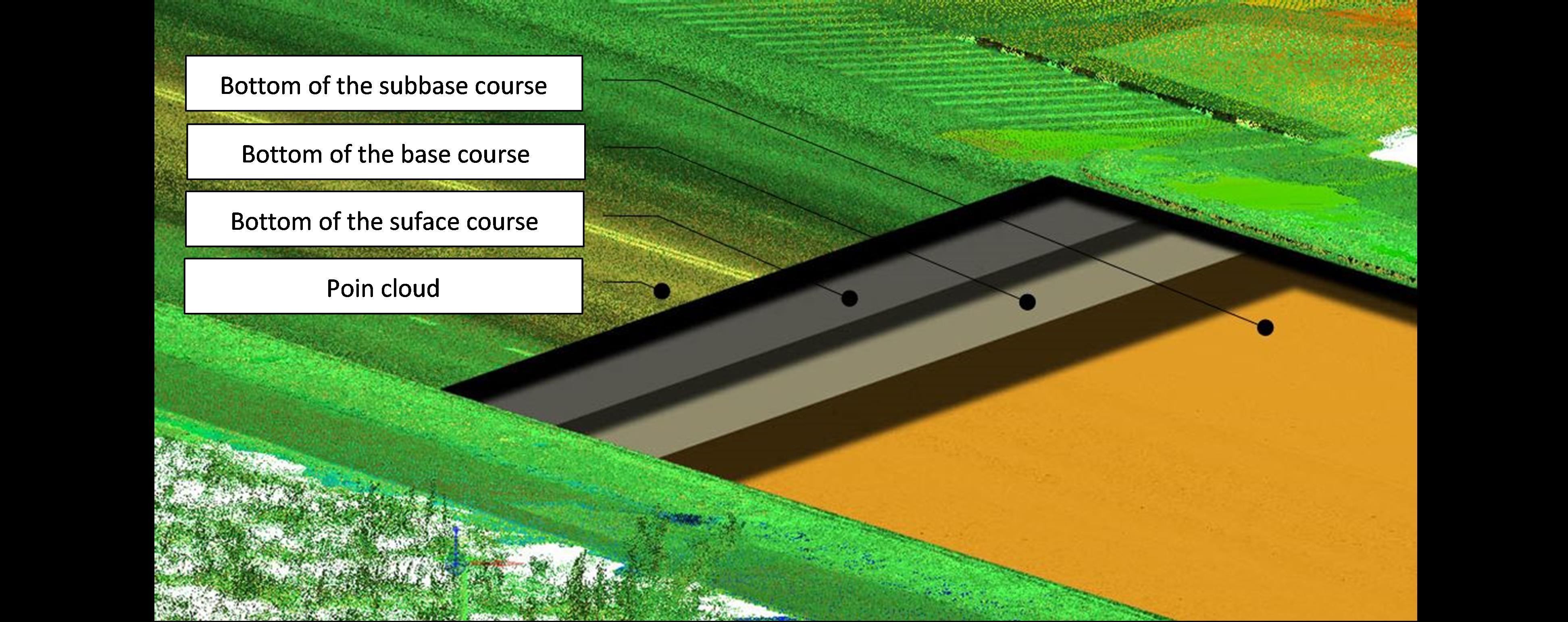
Figure 4 - Three-dimensional representation of the interfaces between layers of pavement, combined with a point cloud
Similar to the Italian study [7], the experience of information modelling of pavement is presented, including the construction of three-dimensional models of interfaces between structural layers, the search for areas of subsidence of reflective horizons in the base layers, and attributive filling of the information model. At the same time, the list of attributes was proposed as more impressive
In particular, the attributes were divided into three blocks:
- attributes of boundaries (layers)
- attributes of point objects (weakened zones, reinforcement bars, utilities and pipes)
- attributes of boreholes
All of these attributes could be related to a greater extent to geophysical information, in particular:
- GPR profile file name;
- the name of the layer (layer material) or local object
- layer properties (dielectric constant and/or EM wave velocity)
- numbers or mileage of A-scans, as well as the time and date of their recording
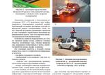
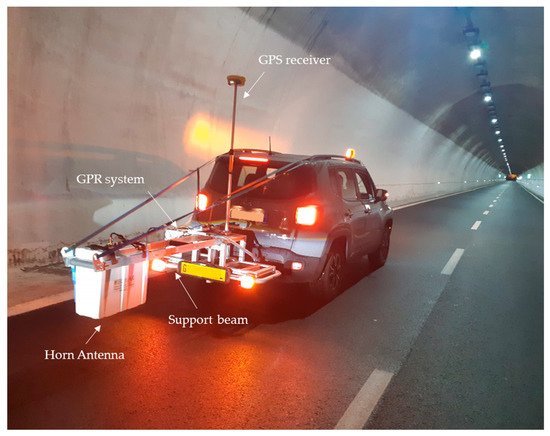
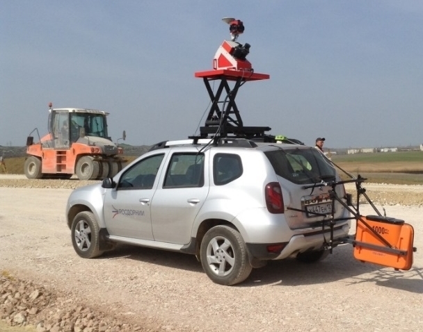
It should be noted that all the pavement models described above were built by obtaining information about the subsurface environment using single-channel GPR, when the spatial picture is formed by duplicating a large number of parallel passages along the road. The appearance of mobile complexes that performed the data collection is shown in Figure 5. Based on the photograph of the Italian complex (Fig. 5) presented in the article [8], it may be concluded that the collection of GPR data and point cloud was carried out separately. At the same time, explained experience shows the possibility of integrating the specified equipment on a single automotive platform (Fig. 5)
a) b)
Figure 5 - Appearance of mobile complexes: a - Italian complex (GPR and GNSS); b - Russian complex (GPR, GNSS and MLS)
To create a digital model of the relief based on a point cloud, one drive along two lanes of the roadway is often enough. To obtain a spatial picture based on the results of a GPR survey, at least three passages along two traffic lanes will be required. At the same time, the detail of the subsurface model will be inferior in the cross-section. It is obvious that the MLS, in this situation, has a much higher performance than GPR. A new type of mobile laboratory equipped with a 6-channel GPR system and a mobile laser scanning system has been developed to overcome this problem (Fig. 6)
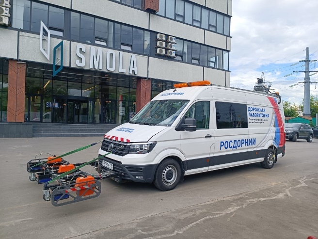
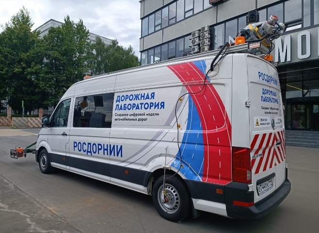
Figure 6 - A new type of mobile laboratory FAI "ROSDORNII"
The new equipment allows the GPR to compete with the mobile scanning system in the detail of the models of the underground environment while increasing the productivity of GPR surveys by several times
METHOD OF CREATING A DIGITAL MODEL OF PAVEMENT
The new methodology for subsurface model-creating was developed to support a new type of mobile laboratory. Also, special software functions were developed for this
The data collection workflow involved driving the GPR along each lane in the forward and reverse directions of the roadway, while the point cloud was recorded only one time for two lanes of the roadway. Data recording was provided jointly by both methods
The technique involved the use of the CREDO 3D SCAN software product (Fig. 7) for working with a point cloud, in particular, for creating a digital elevation model (DEM), projecting the trajectory points onto the relief of the carriageway, as well as export a projected trajectory to the GPR data processing software
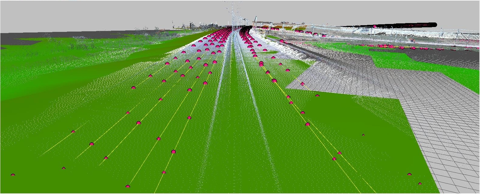
Figure 7 - Projecting the trajectory points onto the relief of the carriageway
The GeoScan32 software was used to collect, georeference and channelize the received GPR profiles
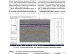
GeoReader software [9], in which the interfaces between pavement layers were modelled, made it possible to perform topographic correction of GPR profiles, taking into account the projected on the relief of the carriageway MLS trajectory. Elevation marks of the road surface were imported to the GPR profiles. Further, directly during the interpretation of the boundaries of the layers (Fig. 8), their height marks were calculated relative to the pavement surface
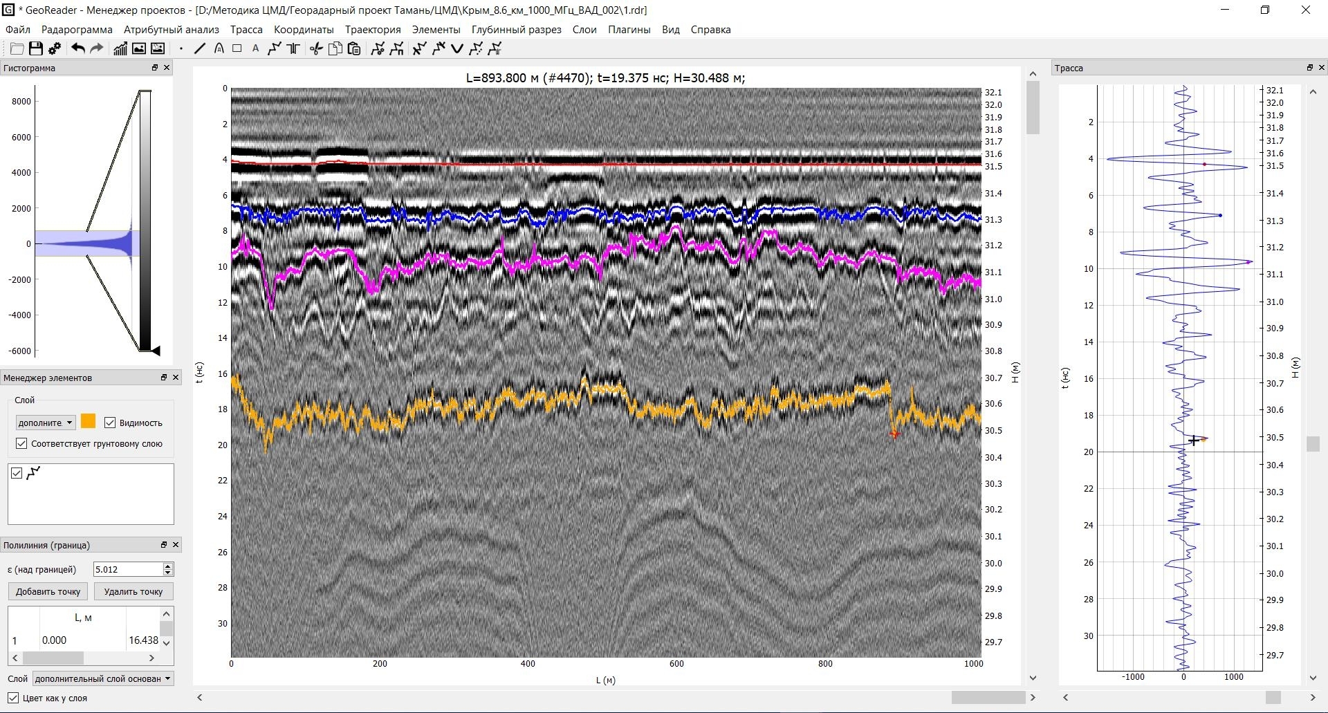
Figure 8 - Interpretation of the boundaries of pavement layers on the GPR profile
By interpolating information between adjacent parallel passages of the GPR profiles, three-dimensional surfaces of the boundaries between the pavement layers were built and exported in the LandXML format
In the same way, the spatial identification of weakened zones is performed in the layers of the subbase of the pavement and subgrade soils. The weakened zones' location can be modelled by three-dimensional bodies in space and by point objects on the map
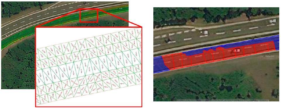
As a demonstration of the possibilities of three-dimensional pavement modelling, a set of office work was carried out by the methodology described above, using as initial data a point cloud and GPR profiles (Fig. 7). The data was recorded on a section of a two-lane highway
Typically used data collection parameters for various equipment are shown in Table 1
Table 1 - Data acquisition parameters for various equipment
| Parameter name | Mobile laser scanner | GPR |
| Coordinate system | GSK 2011, WGS 84 | |
| Scanning frequency, MHz | 0,0001–0,00025 | 500–3000 |
| Survey strip width, m | 100–300 | 0,8–2,7 |
| Maximum scanning depth, m | – | 0,5–5 |
| Scan step along the track, m | 0,05–0,1 | 0,02–0,3 |
| Scan step in cross-section profile, m | 0,02–0,1 | 0,07–1 |
| Data collection speed, km/h | 40–80 | |
.
The appearance of the created 3D model of the pavement, combined with the point cloud, is shown in Figure 9. The figure shows a fragment of the road in the form of a point cloud, in which part of the data is replaced by information about the subsurface structure of the road in the form of a model of pavement layers: asphalt surface, bearing base layer, additional subbase layer
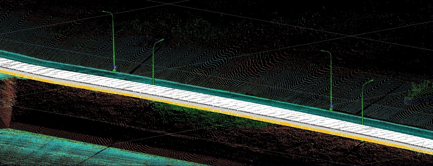
Figure 9 - Appearance of the created 3D pavement model
The image of the model of pavement layers in the longitudinal profile is shown in Figure 10. It can be seen from the figure that the thickness of the pavement layers in the longitudinal profile varies
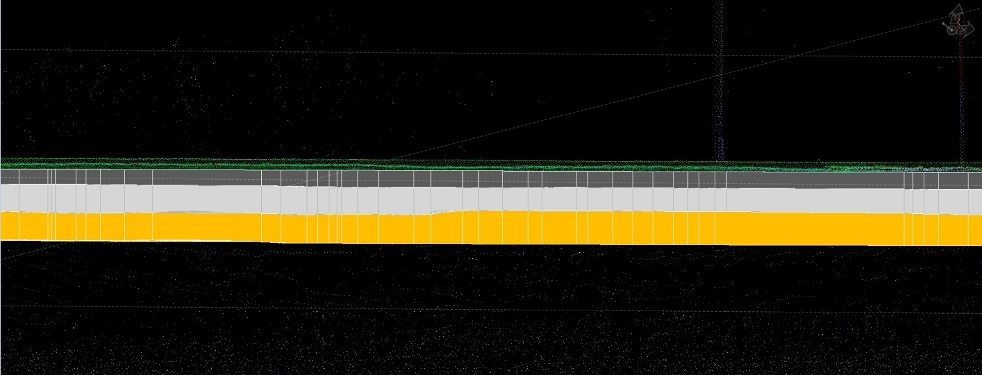
Figure 10 - Model of pavement layers in a longitudinal profile - according to the text above
At the same time, as in the case of any other digital model, it is possible to perform measurement work, namely, determining the thickness of layers in a certain section, the area and volume of the laid material, etc.
One of the cross-sections of the pavement structure, aligned with the point cloud and plotted with the dimensions of the layer thickness, is shown in Figure 11. It can be seen from the figure that the thickness of the layers in the cross-section changes, and thanks to a series of parallel longitudinal GPR passes, it is possible to visualize these changes. Callouts indicate dimensions that show a quantitative estimate of the thickness of the layers in a particular location
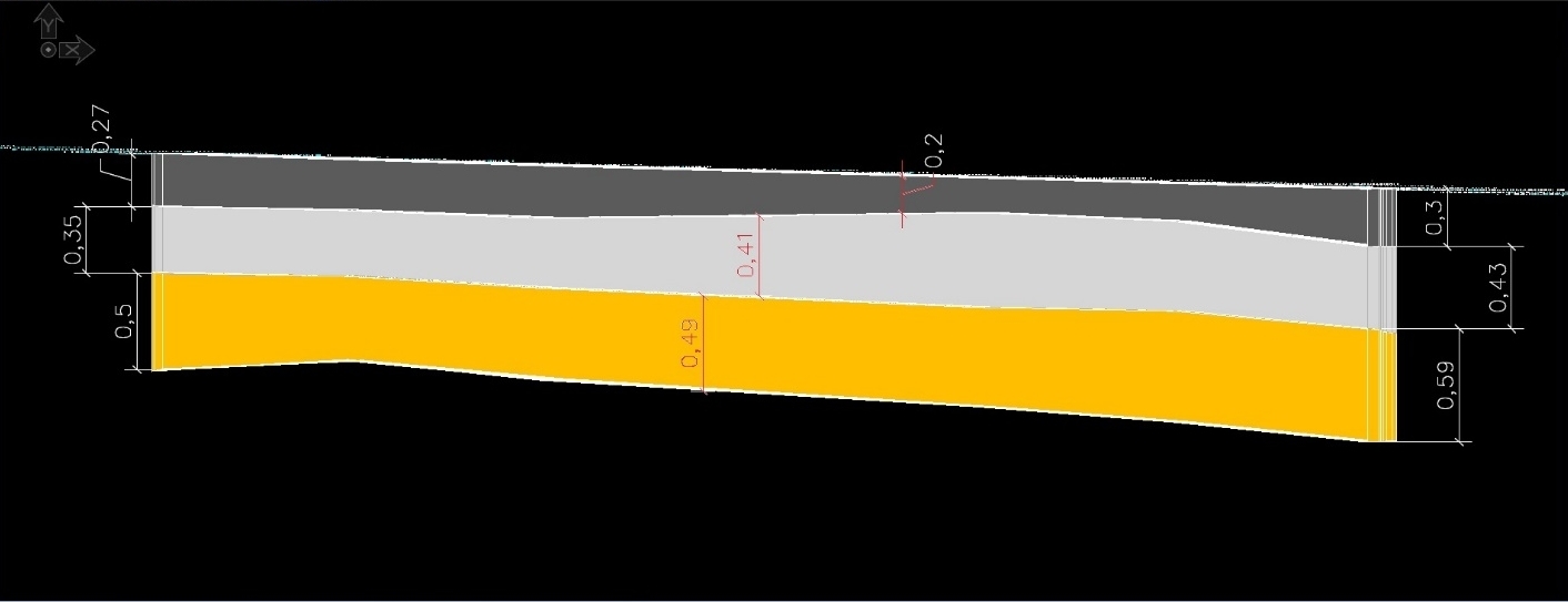
Figure 11 – Cross-section of the pavement model
SUGGESTIONS FOR CREATING ROAD INFORMATION MODEL
For information modelling tasks, it seems promising to represent three-dimensional pavement models in the form of 3D bodies (Fig. 12) in accordance with PNST 505 [1], saturated with attributive information. Attributes of layers of pavement can be both geophysical and engineering information. And if the first one was previously listed in this publication, then the data mentioned in the current industry regulatory and technical base [10]–[13] and others can be attributed to the latter
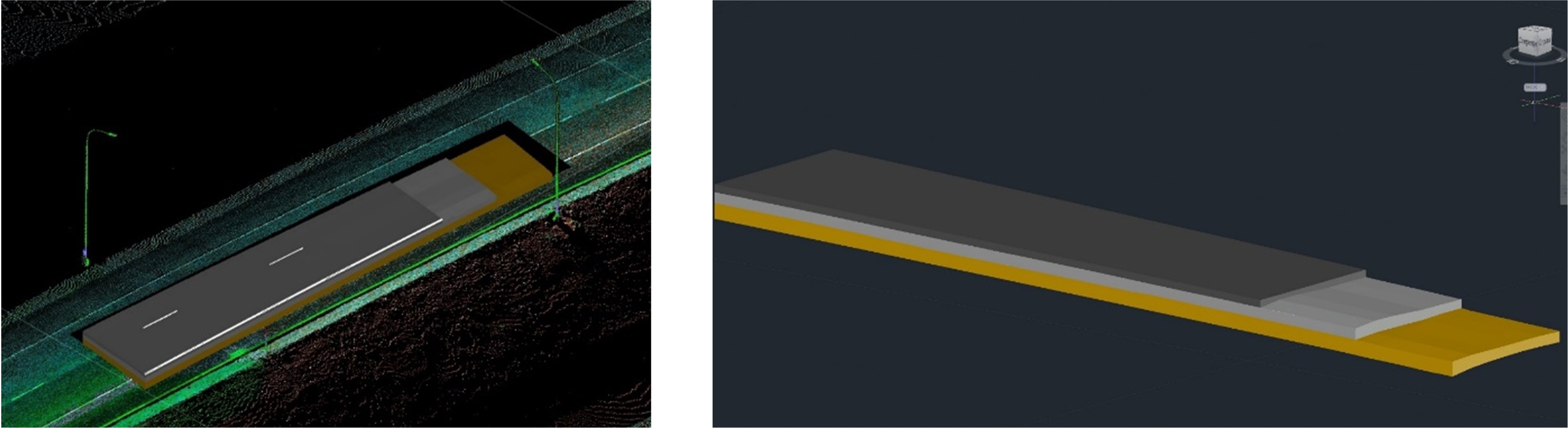
Figure 12 - Three-dimensional pavement models in the form of 3D bodies
An example of the usage of a three-dimensional model of pavement is shown in Figure 13. In accordance with the scale (the legend in the upper right part of the figure), the depth of the bottom of the base layer varies from 0.6 m to 0.8 m. Subsidences are the first sign of weakening of the pavement and also indicate the location of the catchment areas if the layer is arranged on impervious soils
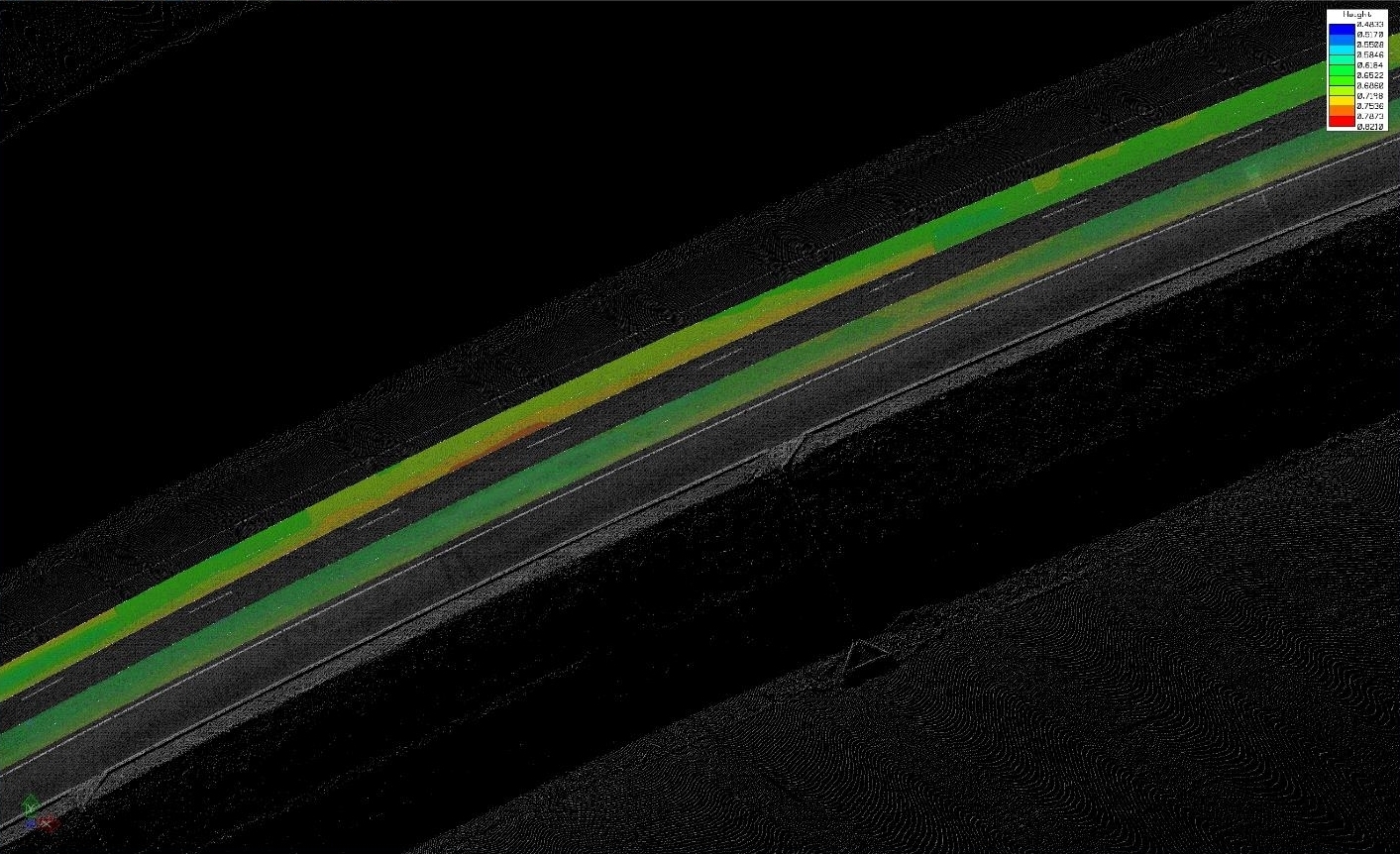
The place of subsidence of the pavement layer is highlighted with a red marker
Figure 13 - Determining the places of subsidence of the pavement
In accordance with the current regulatory and technical documents, the scope of GPR in the road sector is quite wide, and specific tasks are summarized in Table 2
Table 2 - Scope of GPR application
| Survey level | Construction stage | Operational stage |
| Determination of lithological boundaries of different layers [14] | Determination of layer thicknesses, strength and the need for repairs of the pavement [14], [14]–[18] | |
| Groundwater level determination [15], [19] | ||
| Identification of heterogeneities of the geological structure. Determination and detailing of areas having to differ engineering-geological conditions. Identification of drawdown and karst areas. Detection and contouring of weakened zones. Detection and contouring of taliks, overflows and frozen rocks among thawed, individual ice bodies and areas of increased ice content [14]. Determination of the relief of the top of rocky and frozen soils, thickness of non-rocky and thawed overlapping soils [18] |
Determination of changes in the density and moisture content of soils in the layers of the subbase of pavement and subgrade soils [14]. Determination of the state of subgrade soils and the underlying foundation of the highway [17] |
Examination of existing pavement and subgrade structures in order to determine areas of high humidity and decompaction [14]. Determination of the state of subgrade soils and the underlying foundation of the highway [17]. Determination of the boundaries of karst cavities and underground empties in the subgrade and the underlying foundation of the highway. Determination of the boundaries of interpermafrost waters and taliks in the subgrade and the underlying foundation of the highway. Monitoring of landslide and karst processes in subgrade and the underlying foundation of the highway. Determination of weakened zones in soils of natural foundation, assessment of their current activity [18] |
| Assessment of the need for drilling operations, their volumes and determination of drilling sites based on the identified alleged non-conformity locations. Improving the objectivity of the decision made on the conformity of the thickness of the layers of the pavement and the uniformity of the properties of the materials and soils of the subgrade to the design data by obtaining complete, continuous and more detailed information about the pavement. Increasing the durability of road structures by justifying the reduction in the volume of work on the excavation of control workings by destructive methods [19] | ||
| Determination of continuous geophysical information on the thickness of ice and the depth of the water flow both in the longitudinal and cross-section directions to the axis of the ice road. Determination of the thickness of natural, frozen and snow ice along the entire length of the ice road [20], [21] |
||
.
Based on the analysis of Table 2, it can be noted that in the information modelling of pavements based on the results of GPR survey, the model can be used to determine the structure of the pavement, assess its compliance with design parameters, detect existing weakened zones, determine the need for repair or replacement of structural layers
The formation of an information model is proposed to be carried out mainly during the construction or reconstruction of pavement, in some cases at important objects - during major repairs. Work on updating pavement models can include two successive stages: preliminary and detailed analysis. As part of the preliminary analysis, a planned update of the pavement information model is carried out, taking into account previously received information: the primary information model or the model of the previous stage, as well as the results of work performed earlier by destructive methods. During detailed surveys, together with GPR survey and laser scanning, additional studies are performed: FWD and control drilling
From a technical point of view, there are limitations to the technology associated with the lack of information about the road structure near the edges and under the roadsides when performing longitudinal GPR runs along traffic lanes. At the same time, these elements are less susceptible to loads from passing vehicles
The main limitation hindering the development of information modelling technology for operated road structures is the rather high cost of equipment and work on creating models. For this reason, in order to achieve a significant economic effect in the operation of pavements, work on their information modelling should be massive. For example, it is proposed to start such work on the digitization of road surfaces on the main road network of the Russian Federation
Since pavements are the most expensive and subject to load degradation element of the road, planned monitoring of changes in the state of their structural layers, timely measures to restrict traffic and targeted justified restoration measures will improve pavement safety and compliance with standard overhaul periods
CONCLUSION
Currently, in Russia and abroad, the technologies of GPR and laser scanning of roads for information modelling road pavements have received sufficient development
Pavement information models can detect the prerequisites for forming pavement defects to preventive work to ensure their safety, control the volume of completed road construction work, and justify design decisions
Information models of pavements are recommended to be created at the time of their construction or reconstruction and updated throughout the entire life cycle of the facility. At the time of formation, the information model must contain both the parameters of the geometry of the structural layers (three-dimensional digital model) and their main properties (attributes). Monitoring and updating these characteristics' changes at operating stages is advisable
It is advisable to divide the scope of work on updating information models of pavements into two stages: preliminary and detailed analysis. As part of the first stage, a comparison of data versions for the previous and current periods should be performed. In areas of significant changes in data parameters, it is necessary to perform detailed surveys, including using additional methods: FWD and destructive methods
The tasks that should be solved with the help of pavement information models are the determination of their structure and state in the inter-boreholes space; identification of various kinds of weakened zones and inhomogeneities of properties both in the layers of the pavement and in the soils of the subgrade; as well as control of the compliance of the thickness of the pavement layers with the design solutions
Because of the high cost of pavements and the relevance of the tasks of their safety, it is proposed to implement a phased approach to information modelling of pavements. At the same time, it is advisable to start with the main road network of the Russian Federation. One of the stages of this work is the development of a sectoral national regulatory and technical document - Standard "Public automobile roads. Road clothes. Rules for creating a digital model of the coating surface and internal structure
List of used literature
1. Public automobile roads. Rules for describing the components of information modelling: PNST 505-2022 / FAI "ROSDORNII". - M., 2022. - 32 p.
2. Public automobile roads. Rules for the formation and application of information models at various stages of the life cycle: PNST 506-2022 / FAI "ROSDORNII". – M.,
2022. - 32 p.
3. Saarenketo, T. Road evaluation with ground penetrating radar / T. Saarenketo, T. Scullion // Journal of Applied Geophysics. - 2000. - Vol. 43, nos. 2–4. - P. 119-138.
4. Varin, P. Interview 04/17/2013 (interviewer A. Sediqi) // Senior consultant. – 2013. Transcribed. The City of Tampere. Roadscanners office.
5. Varin, P. Road widening guidelines: a ROADEX IV report for Task D2 "Widening of Roads" / P. Varin, T. Saarenketo. – 2012.
6. Eremin, R. A. Technology of geospatial modelling of GPR data / R. A. Eremin, Yu. A. Sukhobok, N. Yu. Rassadkin // Roads and bridges. - 2018. - No. 38 (1). - S. 144-167.
7. Experience of Information Modeling of GPR Survey Results / R. A. Eremin [et al.] / European Association of Geoscientists & Engineers // Conference Proceedings "Engineering and Mining Geophysics 2019"; 15th
Conference and Exhibition, April 2019. – Vol. 2019. - P. 1–9.
8. Integrating Non-Destructive Surveys into a Preliminary BIM-Oriented Digital Model for Possible Future Application in Road Pavements Management / Fabrizio D'Amico [et al.] // Infrastructures 2022, 7, 10.
9. Sukhobok, Yu. A. Software package for information modelling of GPR data GeoReader / Yu. A. Sukhobok, M. S. Kurbatov // CAD and GIS of highways. - 2019. - No. 2 (13). - 2019. - S. 26–31.
10. Public automobile roads. Pavement. General requirements: GOST R 59120- 2021 / FAI "ROSDORNII". - M., 2021. - 21 p.
11. Crushed stone-gravel-sand mixtures for pavements and foundations of highways and airfields. Specifications: GOST 25607-2009 / OJSC SoyuzdorNII. - M., 2018. - 11 p.
12. Sand for construction work. Specifications: GOST 8736-2014 / FSUE "VNIPIIStrom Raw Materials". - M., 2015. - 10 p.
13. Public automobile roads. Classification of types of terrain and soils: GOST 33063-2014 / FGBI "ROSDORNII". - M., 2016. - 54 p.
14. Public automobile roads. Requirements for conducting engineering and geological surveys: GOST 32868-2014 / FSIE "ROSDORNII". - M., 2015. - 62 p.
15. Public automobile roads. Non-rigid pavement. Assessment Methods strength: GOST R 59918-2021 / Dorinzhservis LLC. - M., 2022. - 54 p.
16. Public automobile roads. Pavement. Methods for measuring the thickness of layers pavement: GOST R 58349-2019 / FAI "ROSDORNII". - M., 2019. - 19 p.
17. Guidelines for the use of GPR in the inspection of road / Ministry of Transport of the Russian Federation, State Road Service of the Russian Federation (ROSAVTODOR). - M., 2003. - 37 p.
18. Guidelines for conducting survey work during the overhaul and repair of highways: ODM 218.2.037-2013 / FSIE "ROSDORNII". - M., 2015. - 99 p.
19. Recommendations for quality control of road construction works by GPR: ODM 218.3.075-2016 / FAI "ROSDORNII". - M., 2016. - 76 p.
20. Public automobile roads. Winter and ice roads. Technical rules for the construction and maintenance: GOST R 58948-2020 / FAI "ROSDORNII". - M., 2020. - 53 p.
21. Guidelines for assessing the carrying capacity of ice roads: ODM 218.4.030-2016 / FAI "ROSDORNII". - M., 2017. - 43 p
The article was received by the editors on 09/09/2022